Birdsville to Poeppel Corner and huge Big Red sand dune

We arrived in Birdsville for two main reasons: to celebrate Nissan’s 50th anniversary of crossing the Simpson Desert and to drive from Birdsville to Poeppel Corner.
Read how we got to Birdsville (part 1) and why Nissan organised this event.
We spent the first few days resting, attending Nissan workshops, enjoying lunch at the Birdsville Bakery, and sipping Birdsville Lager at the Birdsville Pub.

The Birdsville Bakery’s real highlight was the Camel Pie, which was delicious. Honestly, we weren’t sure if it was actually made with camel meat, but we enjoyed it a lot.

Hema’s HX-2 Navigator
Explore Australia with Hema’s HX-2 Navigator, the ultimate GPS system for on and off-road navigation.

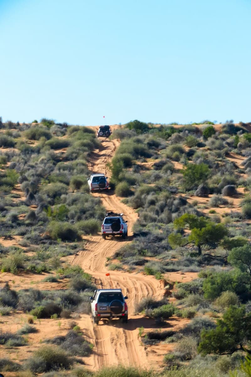
Convoy early start
To prepare our car for the trip through the Simpson Desert, we needed to make a small modification to our cat by installing a 4-meter white pole with a flag at the top.
The purpose of this was to make our vehicle more visible when driving on the dunes, which can have sharp turns and steep inclines. If two cars are climbing opposite sides of a dune, there is a risk of collision, especially if drivers are trying to accelerate uphill to avoid getting stuck in the deep sand.
By having a flag on our car, we could be seen from a greater distance, reducing the risk of accidents. We chose to use a black pirate flag to make our vehicle more distinctive.
We started our journey early in the morning, knowing that we had a long way to go to reach Poeppel Corner. Even though the distance was only 165 kilometers, the track was challenging. We all gathered at sunrise in front of the Birdsville Pub, despite the cold weather. Everyone was ready and no one was late.

Our first goal was to reach the Big Red intersection, which was only 38 km away. At first, the road was mostly dirt, but eventually it narrowed into a track.

Lake Nappanerica
There are two tracks to cross Lake Nappanerica: one that runs directly east of the Big Red and the one we took, which goes via the Little Red sand dune.
Our track followed a path that went through and alongside partially dry lake bed. The vegetation in the area gave the lake a striking maroon color, which we had never seen before.

We found out later that the other track, which ran east of Big Red, was completely underwater. We were glad that we had taken the other route, as attempting to drive through the flooded track would have surely led to getting stuck.

After crossing the Little Red sand dune, we stopped to take an incredible photo of the desert. We were amased by how far we could see along the narrow track.

On this trip, we only passed by the famous Big Red, as our plan was to attempt to climb it on the way back from Poeppel Corner.
We couldn’t resist stopping for a few photos, though. The massive red sand dune towered over us, making us feel small in comparison. We were eager to return and tackle it on our way back.

Driving through sand dunes
The track to Poeppel Corner took us across several sand dunes, which meant we had to climb up and down each one. Some of the dunes were extremely soft, and we knew there was always a possibility of getting bogged. Nevertheless, we pushed on, eager to reach our destination.
Despite the challenging terrain, we took two breaks on our way to Poeppel Corner. During the first break, we stopped to admire the vast expanse of the desert. The sand stretched out as far as the eye could see, and the only sound was the gentle rustle of the wind blowing across the dunes.
During our second break, people in our group had to stop and check their car. They discovered that the fuses in their radios had blown, causing their radios to go suddenly silent.

Despite the relatively short distance, it took us a grueling seven hours to reach Poeppel Corner. The landscape was like nothing we had ever seen before, with endless sand dunes and sprawling white salt lakes that made the terrain especially challenging.
As we pressed on through the harsh desert, we couldn’t help but wonder if we would tackle it on our own.
Fortunately, we were part of a convoy and we all worked together to navigate the treacherous terrain. We even had a trailer in our convoy and they managed to successfully cross all the sand dunes.


Poeppel Corner
Reaching Poeppel Corner was truly an achievement, as this is the point where three different states and territories meet: Queensland, South Australia, and the Northern Territory.
We stood there and studied the concrete post with its metal top, which marked the exact spot where the borders converged. It was fascinating to think that, if we had three legs, we could stand in three different states at the same time.
But Poeppel Corner is more than just a geographical oddity – it also has a rich history.

Poeppel Corner History
So, why is it called Poeppel Corner?
In 1879, Augustus Poeppel was a surveyor who worked on establishing the border between Queensland and South Australia.
He used pegs and mileposts made of waddi trees to mark the distance every quarter mile (400 meters) starting from Haddon Corner (which is South Australia’s border with New South Wales).
Augustus reached the intersection of the three states in 1880 and marked the spot with a 2.1-meter coolabah tree trunk. This trunk was dragged for 92 km by camels across salt lakes and sand dunes from the Mulligan River area.
Interestingly, his corner peg was placed 274 meters away from the current position of Poeppel Corner, due to a measurement error.
In 1883, another surveyor named Larry Wells resurveyed the area and relocated the corner peg to its current position. However, over time the corner peg deteriorated because of the harsh conditions of the desert and eventually disappeared from the landscape.
It was only in 1962, during Dr Reg Spring’s famous Nissan crossing through the Simpson Desert, that the peg was found buried in the dust and damaged by white ants. He replaced the peg with a 44-gallon drum and took the original peg to Adelaide where it rests in the History Trust of South Australia’s relic collection.
Read more about Dr Reg Spring crossing and why we came to Birdsville.
Bill Haylock created the current version of Poeppel Corner by placing a new marker in the correct location on August 25th, 1968. This marker consists of a metal post with three arms pointing in the direction of each state and territory.
It is now a popular destination for travelers and tourists visiting the Simpson Desert and is considered a significant landmark in Australian history.
The area around Poeppel Corner is part of the Simpson Desert, which is the world’s largest sand dune desert covering an area of 176,500 square kilometers.

Camping at Poeppel Corner
Our campsite was located not far from the corner of the three states, on the empty piece of land without any facilities. The night was not bad, cold as usual but without any drama.

When you camp in the desert, open your bonnet on the arrival. Mice may try to get to the warm engine, rest there and bite your cables. By opening your bonnet you cool down the engine quickly.
A funny thing happened at night.
We slept in a tent and heard dingoes howling throughout the night. At one point, a dingo tried to push open our tent with its nose, which was quite frightening.
Kasha woke up and tied the zipper ends together with a shoelace to prevent any further attempts to open the tent.

Conquering the Big Red
The way back was not that challenging anymore as we had some practice already. We learned that sand dune driving is not that bad, considering your car is serviced and you take it easy.
We arrived at Big Red in the early afternoon, and the first thing on everyone’s mind was to conquer the massive sand dune.

There were three ways to get there. The first one was a chicken way, as the incline was very gentle and everybody could do it. The second option was the straight-up way with a steep but steady incline.
The last option was for the crazy 4WD drivers. It was situated on the steepest part of the Big Red. Some drivers attempted this way and actually succeeded.
I chose the middle option, and even though I had two diesel cans, a wheel, and a box on the roof, I managed to make it up on the first attempt.

Interestingly, I tried two more times later on, and I failed. Beginners luck? Maybe.
The view from the Big Red was great and we finished the day with some achievements. We stayed for the night at the bottom of Big Red and went to bed early.
Big Red is home to the most remote music festival called Big Red Bash. Staged in July, every year it brings around 10000 people from every corner of Australia.

Sunrise at Big Red Sand Dune
Kasha woke up early and bravely captured some amazing photos just before sunrise. The colors of the morning, the distant lake, and the golden Big Red dune we camped next to made for a breathtaking sight.
After breakfast, we made our way back to Birdsville for the final celebration day and concert on Saturday. Following the festivities, we began the long drive back home to Brisbane.


Birdsville to Brisbane – On the way back
Our time in Birdsville was very unique. We did a lot of different activities such as 4WD workshops, recovery training, 4WD driving to Poeppel Corner, having dinner and drinks at Birdsville Pub, trying Camel Pie, and attending the Nissan celebration.

The weather was harsh and not really our favourite. However, we still remember this trip well as it was something we had never done before.
On our way back home, while driving towards Quilpie, we almost crashed into a group of kangaroos on the road. It was quite unexpected encounter. Later, we stopped in Windorah to refuel and the rest of the road trip was just boring driving on Warrego Highway without any problems.


It took us almost two weeks, but we reached Poeppel Corner – quite an achievement, don’t you think?
If you have been to Birdsville or have crossed the Simpson Desert, please leave a comment below!
From red dirt to tropical rainforest. Ten places anyone should add to their bucket list. Subscribe and receive ten colourful infographics.
Please subscribe to receive our monthly newsletter
Enjoy outdoors with new equipment


Did you like our content?

4WD Equipment Checklist
GPS Navigator or compass
Maxtrax – if you get bogged, you can use it for additional traction
Tire Deflator – deflate tires quickly when going on dirt or 4WD
Air Compressor – inflate tires quickly after going back on bitumen (we use MM)

Tire Repair Kit – to fix the tire by yourself when you don’t have access to the tire shop (we use Oztrail)
UHF Radio – for communication with your mates and in emergency
Full Recovery Kit (with Dampener Blanket) – must-have if you are going on real off-road
High Lift Jack – useful if you do serious 4WD tracks
Shovel – useful if you get bogged, also good for campfire cooking
Fuel funnel with water filter – additional protection when fueling up in dodgy places
Read more from our travel guides
Are you planning a trip to Northern Territory? – Read our comprehensive travel guide
Are you planning a trip to Western Australia? – Read about everything you need to know


